
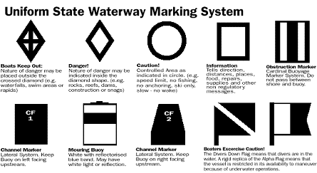
Aids to Navigation and Their Meanings
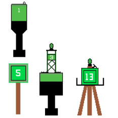
A Can Buoy marks the right side of the channel Leaving a harbor. It will be Green
and have odd numbers on it.
Green Daymarkers are often used in shallow areas for the same purpose.
If the green marker has several pilings supporting it, it will be called a Dolphin.
Green Buoys with lights will usually be found in deeper waters.
The light will be green.
Larger Buoys may also have bells, horns or other sound producing devices.
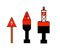
A Nun Buoy marks the Left side of the channel leaving the harbor. It will be red and have even numbers on it. Red Daymarkers are often used in shallow areas for the same purpose..
If the red marker has pilings supporting it,
it will be called a dolphin. Red buoys with lights will usually be found in deeper water.
The light will be red. Larger buoys may also have bells, horns or other sound producing devices.
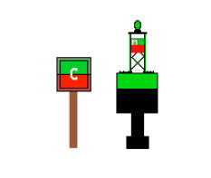
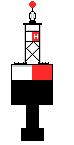
Preferred channel markers are a combination of red and green.
Years ago, this marker was known as a junction marker.
Preferred channel markers are a combination of red and green.
Years ago, this marker was known as a junction marker.
That is, if the top color is red treat it as a red marker. Just as with red and green markers, they may be found as daymarks or floating buoys. They will have the same color light at the top color of the marker, and they may have letters, but not numbers.
Preferred channel markers are a combination of red and green.
Years ago, this marker was known as a junction marker.
Preferred channel markers are a combination of red and green.
Years ago, this marker was known as a junction marker.
That is, if the top color is red treat it as a red marker. Just as with red and green markers, they may be found as daymarks or floating buoys. They will have the same color light at the top color of the marker, and they may have letters, but not numbers.

Special purpose markers are Yellow and
may serve a wide range of uses.
These may include, but are not limited to,
dredging, fish trap areas, spoil areas or
Military excercise areas.
Range Markers are found in pairs with one higher than the other.
Range markers indicate the center line of a channel by having them lined up as you pass through the channel
They will have vertical colored panels to assist you in lining them up.

Some markers have no lateral significance.
They are not designed to indicate the channel, but rather to help you know where you are.

White markers and or buoys with an
orange, diamond, circle, or square can be used to provide information or regulations such as a no wake zone
or a shoal area..
As with all other aids to navigation, they should be given a wide berth to avoid possible damage to your vessel.

U. S. Aids to Navigation System (ATON)
Buoys and markers are the “traffic signals” that guide boat operators safely along some waterways. They also identify dangerous or controlled areas and give directions and information. As a recreational boat operator you will need to know the lateral navigation markers and non-lateral markers of the U. S. Aids to Navigation System.
Lateral Markers
These navigation aids are used to mark the edges of safe water areas; for example, to direct travel within a channel. They use a combination of colors and numbers which may be applied to buoys or permanently placed markers.
- Red colors, red lights, and even numbers indicate the right side of the channel as a boater enters from the open sea or heads upstream.
- Green colors, green lights and odd numbers indicate the left side of the channel as a boater proceeds from the open sea or heads upstream.
- Red and green colors and/or lights indicate the preferred (primary) channel. If green is on top, the preferred channel is to the right; if red is on top, the preferred channel is to the left.
- Lighted Buoys use the lateral marker shapes, colors and numbers discussed above; in addition, they have a matching colored light.
- Nuns are cone-shaped buoys marked with red colors and even numbers.
- Cans are cylindrical-shaped buoys marked with green colors and odd numbers.
- Daymarks are permanently placed signs attached to structures such as posts in the water. Common daymarks are red triangles (equivalent to nuns) and green squares (equivalent to cans) and may also be lighted.
- Red Right Returning is a reminder of the correct course when returning from open waters or heading upstream.
- While originally intended for police boat operators, this mini-course is designed to provide all Small Boat Professionals with the basics of navigation. Divided into modules, this free, online tutorial allows the student to chip away at the subject at a comfortable and steady pace. Each module builds on the ones before it and learning is reinforced with numerous illustrations, examples, and exercises.
- The online training course provided by the United States Coast Guard Auxilliary.
Aids To Navigation
Waterway Marking Systems Channel Buoys.
Lateral System (Federal)
The waters of the United States are marked for safe navigation by the lateral system of buoyage. This system employs a simple arrangement of colors, shapes, numbers and light characteristics to show the side on which a buoy should be passed when proceeding in a given direction. The characteristics are determined by the position of the buoy with respect to the navigable channels as the channels are entered from seaward.
The expression “red right returning” has long been used by the seafarer as a reminder that the red buoys are passed on the starboard (right) side when proceeding from the open sea into port (upstream). Likewise, green buoys are passed on the post (left) side, Conversely, when proceeding toward the sea or leaving port, red buoys are passed on the port side and green buoys on the starboard side. Red buoys are always even-numbered. Green buoys are odd-numbered. Red and white vertically stripped buoys mark the center of the channel.
Mooring to Buoys
Tying up to or hanging on to any navigation buoy (except a mooring buoy) or beacon is prohibited.
Aids to Navigation
In recent years, modification to certain aids to navigation located on coastal and inland waters have been completed. These changes apply to aids used in both the lateral and state waterway marking systems. See charts that follow:
- Port-hand buoys are painted green, with green fixed or flashing lights.
- Starboard-hand buoys are painted red, with red fixed or flashing lights.
- Safe water buoys, also called midchannel or fairway buoys, and approach buoys are painted with red and white vertical stripes, with flashing lights.
- Preferred channel, or junction buoys, are painted with red and green horizontal bands, with flashing lights.
- Special marks (traffic separation, anchorage areas, dredging, fish net areas, etc.) are painted yellow. If lighted, the light may be fixed or flashing.
Uniform State Waterway Marking System
Federal Channel Marking System (Lateral System As Seen Entering From Seaward)
Inland Navigation Rules Of The Road
NAVIGATION CHART NOTES
SCALES & SOURCES
- Large Scale: the fraction is larger (ie: 1/100,000); a closer view
- Small Scale: the fraction is smaller (ie: 1/500,000); shows more area
Chart Sources:
- NOS - Great Lakes and coastal waters of US
- DMAHTC - high seas and foreign water
- CORPS of ENGINEERS - major inland rivers, canals, lakes
COLORS:
- Gold = land areas on NOS charts
- White = water
- Blue = shallow water areas
- Green = submerged water areas that uncover (tidal)
- Magenta = lighted buoys, red buoys, caution and danger symbols, compass roses
- Black = most symbols and printed information
- Gray = land areas on DMAHTC
LETTERING:
- Vertical objects dry at high water, not affected by movement of water
- Leaning/Slanting features in water, underwater, or floating; not depth figures
CHART DATUM
- Mean Low Water = average of all lowest water levels for 19 years---blue tint out to depth contour that is considered a danger contour for majority of marine traffic expected to use the chart
- Mean High Water = Line shoreline---datum used for vertical clearances of bridges
- Low Water Line = single row of dots, other contours represented by a series of dots or dots and dashes (see Chart No. 1)
- Range Lines = solid over navigated portion, dashed where it should not be followed
CHART TYPES
- Smallest scale = long stretches of coastline, open ocean between ports
- General = more limited area of coast, coastwise navigation, within sight of land
- Coast Chart = close-in coastwise navigation, entering and leaving harbors
- Harbor = largest scale, most detailed, navigation within harbors
- Small-craft Chart = compact, small-size, folded, public marine facilities available
Signals For Restricted Visibility
- Long ------(four to six sec.); Short -(one sec.)
- SIGNAL: HORN EVERY TWO MINUTES (Underway) 1 Long -----
- SIGNAL: BELL EVERY MINUTE (Anchored or Aground)
- Underway (Rule 35a) 5 sec At Anchor (Rule 35g INT) (Rule 35f INL))
- Underway but stopped (Rule 35b) 2 Long ----- -----
- At Anchor (optional) (Rule 35g INT (Rule 35f INL) 1 short - 1 Long ----- 1 short -
Not under command
- Restricted in ability to manuever*
- Sailing
- Fishing*
- Towing or pushing
- Constrained by draft** (Rule 35c&d INT) and (Rule 35c INL)
- HORN 1 Long - 2 Short
- At anchor: vessel greater than 100 Meters (Rule 35g INT) and (Rule 35f INL)
- Bell 5 sec.forward
- Gong 5 sec. aft
No Signal Required:
- Vessels less than 12 Meters (Rule 35i INT) and (Rule 35h INL) Each
- But must have sounding device at hand
- Each Aground: (Rule 35h INT) and (Rule 35g INL)
- 3 BELLS EACH
- 1 BELL 5 sec.
- 3 BELLS EACH
Pilot Vessel (Rule 35j) and (Rule 35h INL) HORN 5 SHORT - - - - -
- Aground, vessel greater than 100 Meters (Rule 35h INT) and (Rule 35g INL)
- 5 sec. 3 BELLS EACH, 1 BELL 5 SEC., 3 BELLS EACH
- 1 GONG 5 SEC. AFT.
A towed vessel if manned (immediately after towing vessel signal) (Rule 35e INT)
- (Rule 35d INL) Inland Waters Only: HORN 1 LONG -----, 4 SHORT - - - -
First three signals above are not required for vessels anchored in a special anchorage area designated by the Secretary for:
- Vessels less than 20 Meters,
- Barges, canal boats, scows or other non-descript craft (Rule 35j INL)
INT = International Waters
- INL = Inland Waters
- Underway or at anchor--Inland Waters
- International Waters Only
A Free online navigation course. A Great deal of useful information about navigation.
- Maptech. Add maps and charts to your website for free.