
Weather
- Harbor Tides: Provides tidal information for U.S. waters.
- Accuweather: One of the best.
- Coast Weather: Makes 7 day weather and wave forecasts, and charts for the coastal States and offshore
- Weather terms explained: The kind of information you need to understand marine forecasts. Excellent graphics
- Weather Terms. A dictionary of weather terms.
- Weather Underground: Weather and radar for any U.S. city.
- Shortcuts to NOAA: Marine text and radio fax products and services.
- NOAA Weather. Satellite images and 3D images. Local marine weather forecasts.
Weather Indicator Pennants
Weather pennants appear either individually or as doubles.
When displayed as a pair they indicate a more severe warning.
Small Craft warning up to 38 MPH winds
Gale Warning 39 to 54 MPH winds
Storm Warning 55 to 73 MPH winds
Hurricane Warning 74 + MPH winds
The Saffir-Simpson Hurricane Scale
Courtesy of the National Hurricane Center
The Saffir-Simpson Hurricane Scale is a 1-5 rating based on the hurricane’s present intensity. This is used to give an estimate of the potential property damage and flooding expected along the coast from a hurricane landfall. Wind speed is the determining factor in the scale, as storm surge values are highly dependent on the slope of the continental shelf in the landfall region. Note that all winds are using the U.S. 1-minute average.
Category One Hurricane:
Winds 74-95 mph (64-82 kt or 119-153 kph). Storm surge generally 4-5 ft above normal. No real damage to building structures. Damage primarily to unanchored mobile homes, shrubbery, and trees. Some damage to poorly constructed signs. Also, some coastal road flooding and minor pier damage. Hurricanes Allison of 1995 and Danny of 1997 were Category One hurricanes at peak intensity.
Category Two Hurricane:
Winds 96-110 mph (83-95 kt or 154-177 kph). Storm surge generally 6-8 feet above normal. Some roofing material, door, and window damage of buildings. Considerable damage to shrubbery and trees with some trees blown down. Considerable damage to mobile homes, poorly constructed signs, and piers. Coastal and low-lying escape routes flood 2-4 hours before arrival of the hurricane center. Small craft in unprotected anchorages break moorings. Hurricane Bonnie of 1998 was a Category Two hurricane when it hit the North Carolina coast, while Hurricane Georges of 1998 was a Category Two Hurricane when it hit the Florida Keys and the Mississippi Gulf Coast.
Category Three Hurricane:
Winds 111-130 mph (96-113 kt or 178-209 kph). Storm surge generally 9-12 ft above normal. Some structural damage to small residences and utility buildings with a minor amount of curtainwall failures. Damage to shrubbery and trees with foliage blown off trees and large tress blown down. Mobile homes and poorly constructed signs are destroyed. Low-lying escape routes are cut by rising water 3-5 hours before arrival of the hurricane center. Flooding near the coast destroys smaller structures with larger structures damaged by battering of floating debris. Terrain continuously lower than 5 ft above mean sea level may be flooded inland 8 miles (13 km) or more. Evacuation of low-lying residences with several blocks of the shoreline may be required. Hurricanes Roxanne of 1995 and Fran of 1996 were Category Three hurricanes at landfall on the Yucatan Peninsula of Mexico and in North Carolina, respectively.
Category Four Hurricane:
Winds 131-155 mph (114-135 kt or 210-249 kph). Storm surge generally 13-18 ft above normal. More extensive curtainwall failures with some complete roof structure failures on small residences. Shrubs, trees, and all signs are blown down. Complete destruction of mobile homes. Extensive damage to doors and windows. Low-lying escape routes may be cut by rising water 3-5 hours before arrival of the hurricane center. Major damage to lower floors of structures near the shore. Terrain lower than 10 ft above sea level may be flooded requiring massive evacuation of residential areas as far inland as 6 miles (10 km). Hurricane Luis of 1995 was a Category Four hurricane while moving over the Leeward Islands. Hurricanes Felix and Opal of 1995 also reached Catgeory Four status at peak intensity.
Category Five Hurricane:
Winds greater than 155 mph (135 kt or 249 kph). Storm surge generally greater than 18 ft above normal. Complete roof failure on many residences and industrial buildings. Some complete building failures with small utility buildings blown over or away. All shrubs, trees, and signs blown down. Complete destructon of mobile homes. Severe and extensive window and door damage. Low-lying escape routes are cut by rising water 3-5 hours before arrival of the hurricane center. Major damage to lower floors of all structures located less than 15 ft above sea level and within 500 yards of the shoreline. Massive evacuation of residential areas on low ground within 5-10 miles (8-16 km) of the shoreline may be required. Hurricane Mitch of 1998 was a Category Five hurricane at peak intensity over the western Caribbean. Hurricane Gilbert of 1988 was a Category Five hurricane at peak intensity and is the strongest Atlantic tropical cyclone of record.
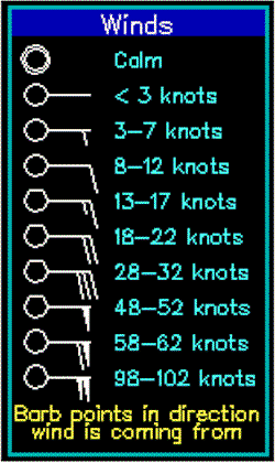
Beaufort Scale of Wind Force and Its Probable Wave Height Created in 1805 by Sir Francis Beaufort is still in use today.
Wave heights quoted below are approximately those that may be expected in the open sea. In enclosed waters the waves will be smaller and steeper. fetch, depth, swell, heavy rain and tide will also affect their height. There is usually be a time lag between any increase in the wind and the consequent increase in the sea.
Beaufort Wind Force Scale
The Beaufort scale of wind velocity was devised by Sir Francis Beaufort (1774-1857), an English admiral and hydrographer. Remember that this scale was originally devised for large sailing craft, and is only a rough guide to what may be expected in open water. Wind speeds are averages, and gusts up to the next Force should be allowed for. Sea conditions are usually more severe nearer to land and wave height can increase dramatically within minutes.
- Always make sure you get a current weather forecast before sailing outside sheltered waters.
- Beaufort No. General Description Sea Criterion Landlubber's Criterion Wind in Knots
- Calm Sea like a mirror. Calm; smoke rises vertically. Less than 1
- 1 Light airs Ripples with the appearance of scales are formed, but without foam crests. Direction of wind shown by smoke drift but not by wind vanes. 1 to 3
- 2 Light breeze Small wavelets, still short but more pronounced. Crests have a glassy appearance and do not break. Wind felt on face; leaves rustle; weather vane moved by wind. 4 to 6
- 3 Gentle breeze Large wavelets. Crests begin to break. Foam of glassy appearance. Perhaps scattered white horses. Leaves and small twigs in constant motion. Wind extends light flags. 7 to 10
- 4 Moderate breeze Small waves becoming longer, fairly frequent white horses. Raises dust and loose paper; small branches are moved. 11 to 16
- 5 Fresh breeze Moderate waves, taking more pronounced long form; many white horses are formed. Chance of some spray. Small trees in leaf begin to sway. Crested wavelets form on inland waters. 17 to 21
- 6 Strong breeze Large waves begin to form; white foam crests are more extensive everywhere. Probably some spray. Large branches in motion; whistling heard in telegraph wires, umbrellas used with difficulty. 22 to 27
- 7 Near Gale Sea heaps up and white foam from breaking waves begins to be blown in streaks. Whole trees on motion; inconvenience felt when walking against wind. 28 to 33
- 8 Gale Moderately high waves of greater length; edges of crests begin to break into spindrift. The foam is blown in streaks. Breaks twigs off trees; generally impedes progress. 34 to 40
- 9 Severe gale High waves. Dense streaks of foam. Crests of waves begin to topple, tumble and roll over. Spray may affect visibilty. Slight structural damage occurs such as slates removed. 41 to 47
- 10 Storm Very high waves with long overhanging crests. Resulting foam is blown in dense white streaks. The surface takes on a white appearance. Visibility affected. Seldom experienced inland; trees uprooted; considerable structural damage occurs. 48 to 55
- 11 Violent storm Exceptionally high waves. The sea is completely covered with long white patches of foam. Everywhere the edges of wave crests are blown into froth. Visibility affected. 56 to 63
- 12 Hurricane Air filled with foam and spray. Sea completely white with driving spray. Visibility very severely affected. Over 63
Description term
Wind speeds
Wave height (m)
Wind
- Calm
- Light air
- Light breeze
- Gentle breeze
- Moderate breeze
- Fresh breeze
- Strong breeze
- Near gale
- Gale
- Strong gale
Wave
- Ripples
- Small wavelets
- Large wavelets
- Small waves
- Moderate waves
- Large waves
- Large waves
- Moderately high waves
- High waves
knots
- < 1
- 1 - 3
- 4 - 6
- 7 - 10
- 11 - 16
- 17 - 21
- 22 - 27
- 28 - 33
- 34 - 40
- 41 - 47
m/s
- 0 - 0.2
- 0.3 - 1.5
- 1.6 - 3.3
- 3.4 - 5.4
- 5.5 - 7.9
- 8.0 - 10.7
- 10.8 - 13.8
- 13.9 - 17.1
- 17.2 - 20.7
- 20.8 - 24.4
Probable
- -
- 0.1
- 0.2
- 0.6
- 1.0
- 2.0
- 3.0
- 4.0
- 6.0
- 7.0
Maximum
- -
- 0.1
- 0.3
- 1.0
- 1.5
- 2.5
- 4.0
- 5.5
- 7.5
- 10.0
Description term
Wind speeds
Wave height (m)
Wind
- Storm
- Violent storm
- Hurricane
- Hurricane
- Hurricane
- Hurricane
- Hurricane
- Hurricane
Wave
- Very high waves
- Exceptionally high waves
- Exceptionally high waves
- Exceptionally high waves
- Exceptionally high waves
- Exceptionally high waves
- Exceptionally high waves
- Exceptionally high waves
knots
- 48 - 55
- 56 - 63
- 64 - 71
- 72 - 80
- 81 - 89
- 90 - 99
- 100 - 109
- 109 - 118
m/s
- 24.5 - 28.4
- 28.5 - 32.6
- 32.7 - 36.9
- 37.0 - 41.4
- 41.5 - 46.1
- 46.2 - 50.9
- 51.0 - 56.0
- 56.1 - 61.2
Probable
- 9.0
- 11.5
- 14.0
- > 14
- > 14
- > 14
- > 14
- > 14
Maximum
- 12.5
- 16.0
- > 16
- > 16
- > 16
- > 16
- > 16
- > 16
HOW TO TELL THE WEATHER
WIND DIRECTION BAROMETER READING WEATHER
- S to SW 30.00 or below & rising slowly Clearing & fair for several days
- S to SE 29.80 or below & Falling rapidly Severe storm-clear & colder in 24 hours
- E to N 29.80 or below & falling rapidly Severe NE gale & rain. Winter-snow & cold wave
- W to 29.80 or below & rising rapidly Clearing & colder
- NW 30.10 to 30.20 & steady Fair, little change for 1-2 days
- SW to NW 30.10 to 30.20 & rising rapidly Fair, warmer-rain in 2 days
- SW to NW 30.20 & above & stationary Continued fair, little temperature change
- SW to NW 30.20 & above & falling slowly Fair with rising temperatures for 2 days
- S to SE 30.10 to 30.20 & falling slowly Rain within 24 hours
- S to SE 30.10 to 30.20 & falling rapidly Increased wind, rain within 12 -24 hours
- SE to NE 30.10 to 30.20 & falling slowly Rain in 12-18 hours
- NE 30.10 to 30.20 & falling rapidly Increased wind, rain within 12 hours
- SE to NE 30.00 or below & falling slowly Summer-no rain. Winter-rain in 24 hours
- SE to NE 30.00 or below & falling rapidly Summer-rian in 24 hours. Winter-rain or snow
- E to NE 30.10 & above & falling slowly Rain will continue for 1-2 days
- E to NE 30.10 & above & falling rapidly Rain, wind-clear & colder within 36 hours